Trail Walking Bad Honnef - Siebengebirge 21km. - Photo
 flip96
flip96

User

© OpenStreetMap contributors
Length
Length
21 km
Max alt
Max alt
452 m
Uphill gradient
Uphill gradient
784 m
Km-Effort
Km-Effort  
31 km
Min alt
Min alt
60 m
Downhill gradient
Downhill gradient
784 m
Boucle
Boucle
Yes
Creation date :
2016-11-15 00:00:00.0
Updated on :
2016-11-15 00:00:00.0

(0 Reviews)

Walking
Walking
6h45
Difficulty : Medium

Scan this QR Code to open this trail in the SityTrail application

FREE GPS app for hiking

Logo SityTrail SityTrail

IGN / Geographical institutes

Download SityTrail from the App Store Download SityTrail from Google Play

Logo SityTrail SityTrail World

The world is yours!

Download SityTrail from the App Store Download SityTrail from Google Play Download SityTrail on Huawei AppGallery

About

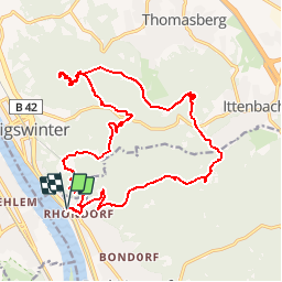
Trail Walking of 21 km to be discovered at North Rhine-Westphalia, Rhein-Sieg-Kreis, Bad Honnef. This trail is proposed by flip96.

Description

Siebengebirge 21km.

Elevation profile

Positioning

Country:
Germany
Region :
North Rhine-Westphalia
Department/Province :
Rhein-Sieg-Kreis
Municipality :
Bad Honnef
Location:
Unknown
Start:(UTM)
373402 ; 5613580 (32U) N.

Trails nearby

Trail On foot Königswinter - Rheinsteig-Zuweg Heisterbacherrott - Photo
On foot
GUIDE+

On foot

Easy
Königswinter, North Rhine-Westphalia, Rhein-Sieg-Kreis, Germany
4.4 km | 6.6 km-effort
1h 29min
No
Trail On foot Königswinter - [B] Beethoven Wanderweg - Photo
On foot
GUIDE+

On foot

Medium
Königswinter, North Rhine-Westphalia, Rhein-Sieg-Kreis, Germany
15.3 km | 24 km-effort
5h 25min
Yes
Trail On foot Remagen - [5] Oberwinter Rundwanderweg - Photo
On foot
GUIDE+

On foot

Easy
Remagen, Rhineland-Palatinate, Landkreis Ahrweiler, Germany
9.1 km | 13.1 km-effort
2h 58min
Yes
Trail On foot Remagen - Oberwinter Rundweg 2 - Photo
On foot
GUIDE+

On foot

Easy
Remagen, Rhineland-Palatinate, Landkreis Ahrweiler, Germany
5.1 km | 6.6 km-effort
1h 29min
No
Trail On foot Wachtberg - Verbindungsweg - Photo
On foot
GUIDE+

On foot

Easy
Wachtberg, North Rhine-Westphalia, Rhein-Sieg-Kreis, Germany
4.8 km | 6.1 km-effort
1h 22min
No
Trail On foot Wachtberg - Dächelsberg-Runde - Photo
On foot
GUIDE+

On foot

Easy
Wachtberg, North Rhine-Westphalia, Rhein-Sieg-Kreis, Germany
7.2 km | 8.9 km-effort
2h 1min
Yes
Trail On foot Bad Honnef - Rheinsteig-Zuweg Bad Honnef (Nord) - Photo
On foot
GUIDE+

On foot

Easy
Bad Honnef, North Rhine-Westphalia, Rhein-Sieg-Kreis, Germany
4.2 km | 7 km-effort
1h 34min
No
Trail On foot Wachtberg - Feuerroute - Photo
On foot
GUIDE+

On foot

Easy
Wachtberg, North Rhine-Westphalia, Rhein-Sieg-Kreis, Germany
3.8 km | 4.5 km-effort
1h 0min
No
Trail On foot Königswinter - Drachenlauf - Photo
On foot
GUIDE+

On foot

Difficult
Königswinter, North Rhine-Westphalia, Rhein-Sieg-Kreis, Germany
25 km | 39 km-effort
8h 50min
Yes


Close
My subscriptions